
LINKS
email me Back to My Homepage.
Cabin Pages
Back to Index for Timberframe Cabin pages.
Back to First Timberframe Cabin page (April-August 2006).
Back to Second Timberframe Cabin page (September - December 2006).
Back to Third Timberframe Cabin page (January- May 2007).
Back to Fourth Timberframe Cabin page (Summer 2007).
Back to Fifth Timberframe Cabin page (Fall 2007).
Back to Sixth Timberframe Cabin page (Winter/Spring 2008).
Back to Seventh Timberframe Cabin page (Summer 2008).
Back to the Eighth Timberframe Cabin page (Fall/Winter 2008-9).
Back to the ninth Timberframe Cabin page (Spring/Summer 2009).
Back to the tenth Timberframe Cabin page (Fall/Winter 2009/2010).
Back to the Eleventh Timberframe Cabin page (Spring/Summer 2010).
Back to the Twelfth Timberframe Cabin page (2011).
Back to the Thirteenth Timberframe Cabin page (2012).
Back to the fourteenth Timberframe Cabin page (2013).
Back to the fifteenth Timberframe Cabin page (2014).My Links to Other People's Timberframe sites.
Useful Offsite Info (Open in new Windows) Fishing with Robert.
 Weather at nearby Old Battle Monitoring Station.
Weather Forecast for Encampment.
NOAH Weather Forecast for approximate cabin location from NOAH.
Southeast Wyoming Road Conditions.
Avalanche forecast for just south of here.
Link to Wyomingtalesandtrails site on are.
My Other Web Pages Trout Unlimited National Website.
 My Philosophy Page.
 My Woodworking Page.
 My Workbenches Page.
 My Old House Page.
 My Kitchen Cabinets Page.
 The Bathroom Remodel Page.
 My Father's Milling Machine.
Wildlife in Wyoming

I last worked on this particular page at the following date and time:
101 Inches on April 17 Ain't Bad.
On April 17, 2016 there are 101 inches of snow at the Battle Pass snow monitor. That monitor is at 10,000 feet. The cabin is at 9,000 feet. You can adjust your estimates as you see fit. But I think that puts us about at normal snow levels for this time of year. Perhaps a bit over.
Not that I made it up there all winter.
But soon . . .
107 inches Well Into May!
Going to be some snow up there for a while yet.
The New York Times Finds Encampment Because Nabokov Did.
The story is here.
The May 30, 2016 article does a nice job with this area. It has nice photos of the Riverside Garage Store inside and out.
Meanwhile Highway 70 is still closed and the snow monitor still shows well over 6 feet of snow 1,000 feet above the cabin. Probably less at the cabin, but not enough less to make a trip up easy.
And on June 9th, Highway 70 Opens!
Or so says the Rawlins Times. It is still going to be a hard slog to the cabin from there, but at least I'll be able to park at the road and hike in pretty soon. I'll bet at least some of our neighbors are already cutting a path to their places.

First Trip of Year
After a very nice trip to Hong Kong for the Lingnan Expressivism Conference and several days in Portland catching up with some friends from college I finally got out here in mid-June. As you can see in the photo above much of the snow had already melted, though the snow monitor 1000 feet higher up and in the trees still showed well over a foot of snow when I got up there.
Most things were in good shape when I arrived, though I was unable to get the yard hydrant to pass water from the utility water tank. Also the water tank coupling for the drinking water tank had shattered even though I had done my best to drain the lines. I guess it doesn't help that they made the part out of pot metal. I'll be redoing the part with a vent to make it easier to drain. But I need to find the right parts first.

Repairing the yard hydrant required digging it and the attached underground PEX up to exam what went wrong. All seemed to be working except for the hydrant itself. I really need a good vise to get it apart. So I spent most of my one full day up there running around looking for another hydrant - one short enough not to need a ten foot hole. Since frost lines are shallow in the mountains (because of the snow) it only needs to go a couple of feet down. The repair was accomplished in the allotted time.


I did have time to explore a bit. One thing I found was a sleeping fawn across the creek. It was so small I thought it was a piece of fur from a winter-killed creature before I recognized it for what it was. It didn't stir and I didn't disturb it. Later on that evening the mother paid a visit to the cabin.

 I also saw what I think was a mink, but the autofocus on the camera got confused so this shot is about as useful as most pictures of the Loch Ness Monster.

A Mycological Interlude
I also looked around for mushrooms. Only the first ones pictured above are known to be edible but I took photos of a few others including one that you definitely should not eat though some people confuse them with morels.


Fire Across the Border at Bear Creek (near the headwaters of Big Creek)
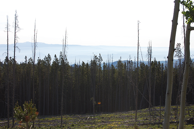

Coming down the mountain Monday morning the valley looked unusually smokey, much like the first picture above which was taken Tuesday morning. On the way back from Laramie where I'd gone to get the parts for the yard hydrant I saw the source of the smoke to the East of Highway 130 just south of the border with Colorado. That's what the second photo above depicts. The fire apparently started on around June 19 and has been burning since. Today on June 26th it is still under 6,000 acres, but it is a serious fire with well over 100 people fighting it using heavy equipment and helicopters.
Federal authorities have set up a website to disseminate news about the fire it is at http://inciweb.nwcg.gov/incident/4797/ It seems to update daily and includes photographs and fire maps. Here is one such map from June 25th:
 Click to go to the original page with the map.
Update on Fire as of 7/10/2016
Short version: Despite relatively favorable weather conditions, the fire has grown to 0ver 15,000 acres as you can see from this map:
 Click to visit the original page with the map.
Firefighters are being cautious about how they fight the fire because of the danger from lots of standing dead beetle-killed pine trees. "For the safety of firefighters, the IMT is allowing the natural process of the fire to occur while focusing their resources on the values at risk. This suppression strategy provides for both firefighter safety and the protection of life and property," according to the latest release at http://inciweb.nwcg.gov/incident/4797/. What they are trying to do makes sense but carries some risks. They seem to be doing well at protecting buildings so far. I'm a little worried that the fire will continue to spread as it has jumped several roads and weather has been getting drier over the past few days. Right now they say it is 5% contained and they estimate it will be controlled on "Friday October 21st, 2016 approx. 12:00 AM." It doesn't seem to me that it can go a lot further east towards WY Highway 230. It has yet to really go over the crest of the forested range that borders the North Platte Valley (broadly construed). If it does it will have to burn downhill and then run into grassland that is pretty green at the moment. But looking West there is a lot of forest with beetle killed trees and it is only 10 miles or so as the crow flies to the Encampment River Wilderness near Hog Park Reservoir in Wyoming. One of my favorite places to fish (the river, not the reservoir which I haven't tried). More about fishing below soon when my phone downloads some photos.
You can get a bit of a sense of the Eastern flank of the fire in these photos taken on July 9th from Highway 230 just as it crosses into Colorado and becomes Highway CO 125. The images don't make things very dramatic, but you can see the smoke from the fire coming over the ridge and in person you get the sense that the fire is burning not to far below it.


Or this official photo seems to give give the same view from a few days ago when it was burning more vigorously:

Added on July 20, 2016

The above map, the full version of which can be viewed at http://inciweb.nwcg.gov/photos/CORTF/2016-06-20-1126-Beaver-Creek-Fire/picts/2016_07_20-18.19.56.392-CDT.jpeg is a useful overview of the progress of the fire over time, from its beginning June 19 until July 20 a month later. I'm hoping they'll get it under control soon. 5% isn't all that comforting even if it isn't moving towards us.
Vacation with Jenny and Fishing with Robert

So in earliest July Jenny and I headed to the cabin to take a week's vacation joining my friend Robert who had preceeded us up there to fish. In addition to being a very good philosopher and a fine fisherman Robert is also an extraordinarily fine guitar player. He brought his early 30s National Duaolian to fill time when he wasn't fishing.
But mostly Robert was there to fish, and I was able to join him several day on the lower Encampment, where we tried to find the green drake hatch, the upper Encampment near the Colorado border where there seemed to be a hatch but the fish were not looking up much (though we each caught and released several brown trout)and Big Creek one morning (where we were skunked completely). Later in the week I did find the green drakes in the upper end of the Encampment and caught a few 12 to 13 inch trout on drake immitations tied in a Wulff style. But still the fish were not visibly feeding on the surface despite swarms of insects (including mosquitos who were looking above the surface for food).
Here's Robert on the Encampment:


I believe he's talking about a fish in the second photo, but I gather it broke off . . .
Jenny and I stayed a while after Robert had gone back to Missouri and we hung out on the porch and did various other things including fishing ourselves.

One day I set off in search of the tailwater below the dam at High Savery Reservoir to the Northwest of us. Google told me it knew how to get there, but it wanted me to go through posted land on a road that looked private. I ran into a couple of people from Texas who had also looked to get below the dam but gave up because every access route they tried passed through private land. I tried a few other options each of which took me through some pretty dicey roads for a Toyota Corolla, but none of which seemed to lead to the right spot. So I gave up and returned to our cabin, hitting a deer along the way which seemed to be no more harmed than the seemingly unscathed car. I guess we were both lucky and that I hit the brakes reasonably well given the circumstances. We both got a scare and he got a smack on the rump, but seemingly not much else happened.
A photo of High Savery Reservoir from the upper end follows. I'll have to come back to find a way to the tailwater later in the summer.

Saw this fawn across the creek one morning. It seems somewhat large to be the same fawn I caught sleeping a month or so earlier. But it is in the right area. Gave me a chance to try out how well the camera on my new cellphone works. It seems pretty good.


Moose In The Creek

There have been moose in the Snowy Range (one range over) since I started coming up here 20 years or so ago. But there were never reputed to be any up here in this range, though I've always thought it was just a matter of time. It would require only crossing the North Platte River Valley to make the journey. Two weeks ago when I was tryig to get to the High Savery tailwater, I noticed a sign along county road 801, Sage Creek Road, that they should be sure not to mistake a Moose for an Elk. This led me to wonder if moose had made it to the Sierra Madre's.
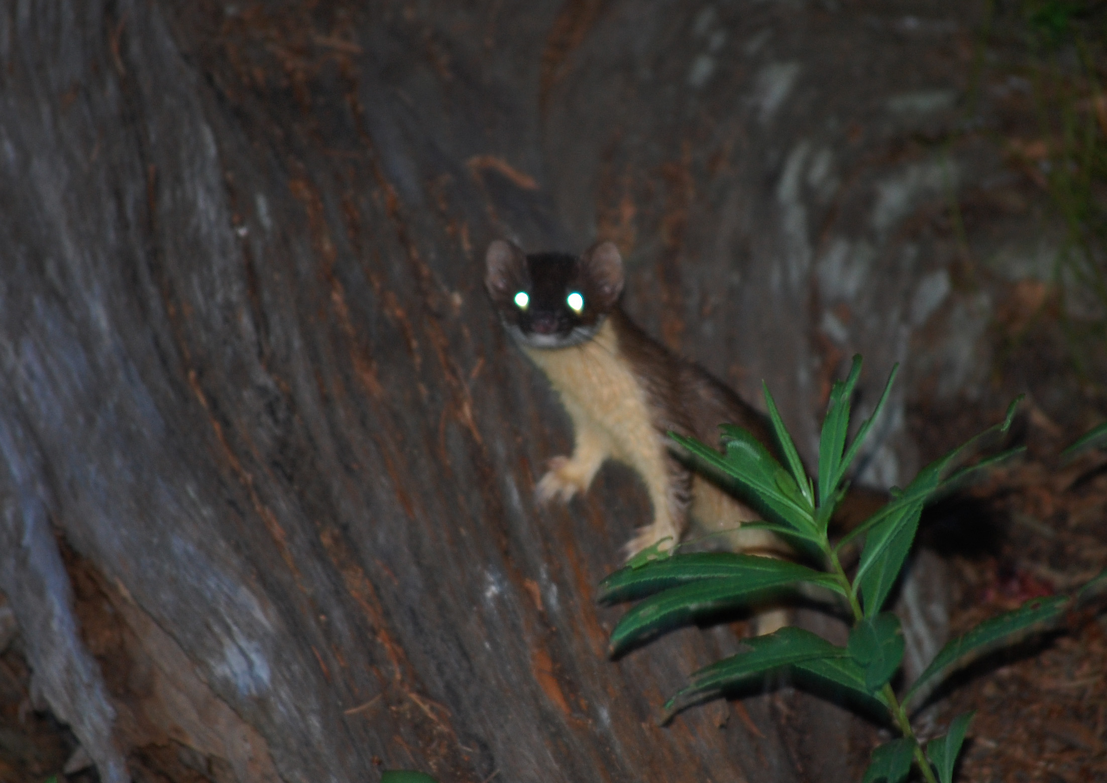
I did not have to wonder long. Two weeks later, on a quick trip to finally find my way to the Savery Creek tailwater, I was hanging out on the porch reading philosophy for work (McHugh and Way, just in case you want to know) when I saw a dark object near the creek through the small opening in the trees I had created last year to look across the creek. At first I thought it was a bear, then an elk, and finally I wondered if it might be a moose. It moved out of sight and I saw a second animal a bit further down the stream, with just its head showing above the steep banks. It looked to be a moose. I took some cellphone photos and then got the good camera and tried to take some more. Low light and long distance made for poor shots, but what you see below are the best of the bunch. You'll note that the moose pictured above is the first animal, while the photos below are of the second.


In the morning they were still around.


And I ran into a weasel with the amzing ability to transform into a demon weasal when the flash on my camera goes off. I think it might be an ermine or a least weasal. It is smallish in any case, not like the larger mink I saw earlier and did such a bad job photographing.

High Savery Tailwater
On the next trip out I did find the way to High Savery Dam and its tailwater. The trick is that you have to follow County Road 602 and eventually go through a gate that you open and shut to go north to the dam. From there it is quite a walk. Nice place when you get there. Caught some nice fish.


Seems like every trip back from High Savery is eventful. This time it was a flock of sheep with a couple of sheepdogs and no visible people. At least this time I didn't hit anything.

A Little Woodworking and Cleaning
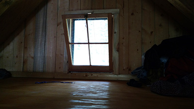
Did get a chance to do just a little woodworking this trip. Trimmed out the back upper window, added a bit of trim at the crown of the back and found room for an additional bookshelf. The last bit was part of a large cleanup/tidy up project that had me vacuum the whole place out, sort through what I needed year round access to and what I probably wouldn't need in the winter. And move the latter to a new small toolbox next to the oldest large one, positioned like a bench for dual use.


Fire News
The Beaver Creek fire is still burning, now (August 2) up to about 34,000 acres in size. It made a move on Parson's Draw just south of the border and they did a miraculous job saving a number of structures. One of my favorite images shows an intact house with a bit of living yard surrounded by burnout. They say good fuel reduction around the house and hard work by the fire crews did the trick. Makes me a bit more comfortable since from what I can tell our near cabin area is as well protected by trimming and raking around the immediate environs.
The image is at
 http://inciweb.nwcg.gov/incident/photograph/4797/3/55157/
The site also has some nice explanations about their strategy for fighting the fire, the latest news, and they now have a facebook page too at https://www.facebook.com/BeaverCreekFire/home
The fire seems to be moving into Wyoming on its Northeast Side due to some high winds that created a spot fire out ahead of the main perimiter and in the Holroyd Park, Wyoming area. It looks like it is just barely across the border and maybe a mile or two from Highway 230. That's getting near the waters of Big Creek above the access area, one of my favorite fishing spots. Mostly sagebrush by the time you get to the highway, but still I'd rather that it didn't get there.
Hmm.

08/15/2016
http://inciweb.nwcg.gov/incident/4955/ is a link to the newly named "Broadway Fire" incident page. This one is perhaps two miles west of the Encampment River and a few miles North of the WY/CO border. Very near my favorite area on the Encampment. Also closer to the cabin than the Beaver Creek Fire. It looks like they may make it part of the same complex for firefighting purposes but it is several (5-8) miles closer to us than the larger Beaver Creek fire. (Officially "- 2 miles N of Wyo/Colo state line, 5 miles W of Blackhall Mtn, 5 miles E of Hog Park Reservoir") It looks like it was lightning caused and about 25 Acres in size at present.
As of September 12, this one seems to be mostly in hand on the West flank along road 496, and continued work along this road to the North will also likely keep it away from our area. The facebook page for the fire at https://www.facebook.com/BeaverCreekFire is a good source of info.
Ack! Now the Snake Fire!
 USFS photo from http://inciweb.nwcg.gov/photos/WYMBF/2016-09-11-1659-Snake-Fire/picts/2016_09_12-10.17.46.702-CDT.jpeg

To the South of us and on the other side of the divide there is a new fire, dubbed the Snake Fire. It is South of the Huston Park Wilderness and looks to be about 8 miles away as the crow flies. It has quickly spread to 2,659 acres in about 3 days. The website to monitor it is at http://inciweb.nwcg.gov/incident/5023/. It is near the Little Snake River which is itself a headwater for the Colorado River and near Battle Creek where we caught Colorado River Cutthroat Trout a couple of years back. Not good, especially since there aren't a lot of roads between it and Highway 70/Battle Highway.
Navigation
Back to Index of the Timberframe Cabin pages.
Back to first Timberframe Cabin page (April-August 2006).
Back to Second Timberframe Cabin page (September - December 2006).
Back to third Timberframe Cabin page (January - May 2007).
Back to the fourth Timberframe Cabin page (Summer 2007).
Back to the fifth Timberframe Cabin page (Fall 2007).
Back to the sixth Timberframe Cabin page (Winter/Spring 2008).
Back to the seventh Timberframe Cabin page (Summer 2008).
Back to eighth Timberframe Cabin page (Fall/Winter - 2008-2009).
Back to ninth Timberframe Cabin page (Spring/Summer 2009).
Back to tenth Timberframe Cabin page (Fall/Winter 2009/2010).
Back to eleventh Timberframe Cabin page (Spring/Summer 2010).
Back to twelfth Timberframe Cabin page (2011).
Back to thirteenth Timberframe Cabin page (2012).
Back to fourteenth Timberframe Cabin page (2013).
Back to the fifteenth Timberframe Cabin page (2014).Back to the sixteenth Timberframe Cabin page (2015).
.
. .